The North and South Twin Mountain trail is a challenging 10.7-mile out-and-back route located at the end of Haystack Road, a short distance off Hwy 3 just east of Twin Mountain. Time to do this trail varies considerably based on individual hikers. Unless you are going to run the trail, expect to spend at least 6 hours to compete both peaks.
The trail starts at the North Twin parking lot at the end of Haystack Road and follows the North Twin Trail for 4.2 miles to reach the summit of North Twin Mountain. Within the first 2 miles of the hike, there are 3 river crossings that can be difficult to cross if the water level is high. From there, you continue along the North Twin Spur for 1.2 miles to reach the summit of South Twin Mountain.
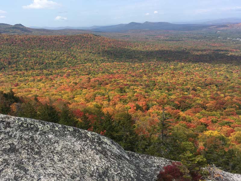
The Sugarloaf Hike (fall picture at the top of this page) is a great option for hikers looking for a moderate hike with stunning views. The trail is suitable for hikers of all levels, but it can be challenging in places. Make sure to bring plenty of water and snacks, and wear sturdy hiking shoes or boots.
The trail is well-marked and well-maintained, but it can be steep and rocky in places, so it is rated as a moderately strenuous hike.
The trail is either a 3 mile hike to the South Sugarloaf or 4.2-mile round-trip hike if you hike the South and North Sugarloaf peaks. The trail takes you through a beautiful forest and fun rock hops and scrambles before reaching the summit.
The final ascent to the summit of Sugarloaf Mountain is a bit steep and rocky topping it off with a ladder climb near the top. Once you reach the top, you'll have amazing views of the surrounding White Mountains. You can see the Franconia Range to the west, Mount Washington to the northeast, and the Twin Mountain area to the south. You can also see the town of Twin Mountain from the summit.
South of Twin Mountain, just as you are entering Crawford Notch, is the AMC Highland Center, a lodging and hiking supply store along with a casual restaurant.
The Mizpah Springs Hut Trail is across the highway (302) from the AMC Highland Center. I has a large parking area, but often fills and you may see cars pared along 302. The Mizpah Springs Trail is a moderate 4.7-mile round-trip hike that takes you to Mizpah Hut in a fairly straight line. Like many of the trails in the White Mountains, you will be hiking uphill going to the hut and downhill the entire way back. This is a very popular trail.
Other trails within 1 mile of the AMC Highland Center in Crawford Notch, New Hampshire include:
Mount Willard Trail - This moderate 3.2-mile round-trip hike starts from the Crawford Depot and takes you to the summit of Mount Willard, where you can enjoy panoramic views of Crawford Notch and the surrounding mountains.
Arethusa Falls Trail - This moderate 3.6-mile round-trip hike takes you to one of the highest waterfalls in New Hampshire, the 160-foot Arethusa Falls.
Frankenstein Cliff Trail - This moderate 4.5-mile round-trip hike offers great views of the valley and surrounding mountains.
Webster Cliffs Trail - This strenuous 6-mile round-trip hike is part of the Appalachian Trail. This trail takes you to the summit of Mount Webster, where you can enjoy panoramic views of the White Mountains. This also connects into the Mount Eisenhower Trail.
Mount Eisenhower Trail - This strenuous 6.8-mile round-trip hike takes you to the summit of Mount Eisenhower, where you can enjoy spectacular views of the Presidential Range.
Make sure to check the trail conditions and weather forecast before heading out on any hike.